EarthVista: Live Satellite Map
- 0.0
- Rating
- 100.00K
- Installs
- Free
- Price
 Analysis by App-foxy
EarthVista: Live Satellite Map is the kind of navigation app that catches my attention before I have decided whether I truly need it. Its combination of 3D Earth views, live cameras, GPS maps, a speedometer, and landmark views creates an inviting first impression. I can open it with a simple question in mind—where is that place, what does it look like, or how far am I moving—and quickly end up exploring somewhere completely different.
After spending time with it, my opinion is more measured. The app is strongest when I treat it as a visual exploration tool with useful navigation extras, rather than as a complete replacement for a dedicated route-planning service. That distinction matters. Its lasting value comes from combining curiosity with occasional practical use, but the novelty of spinning around a 3D globe will not be enough for everyone to keep returning.
Developed by Qzee Games, this free Maps & Navigation app is available to an Everyone audience. It has reached over one hundred thousand installs, runs on Android seven and later, and its current version is 1.2. Those details make it approachable for people using older compatible phones, although the experience will naturally depend on the device’s screen, performance, and GPS behavior.
You May Also Like

 Blood Strike: 2.5 Anniversary
Blood Strike’s Loadouts Turn Every Drop Into a Tactical Gamble
A close look at Blood Strike’s custom loadouts: how fast access to signature weapons reshapes its battle royale rhythm, rewards preparation, and narrows the gap between fights.

 Pandora - Music & Podcasts
Pandora’s Music Is Easy to Start, but Harder to Recover
Pandora’s strength is its low-effort path from a seed to a station. Its weak spot is how much confidence it asks you to place in connection, setup, and quiet recovery.

 8 Ball Pool
 Is Built on Rivalries, Rematches, and Routine
A close look at the rivalries, rematches, shared routines, and unanswered safety questions that turn a quick pool match into a persistent mobile community.

 Samsung Music
’s Quiet Strength Is Playing What You Already Own
Its reach comes less from spectacle than from dependable access to a personal library. That simplicity is both the app’s strongest retention engine and its ceiling.

 AccuWeather: Weather Radar
AccuWeather Review: A Quick, Clear Forecast for Everyday Decisions
For everyday plans, the best forecast is the one you can understand quickly. AccuWeather makes rain timing, radar, and local conditions easy to act on, with a few trade-offs.

 Hill Climb Racing
Why Hill Climb Racing Still Turns Crashes Into One More Run
A tiny car, a bumpy hill and one more upgrade: Hill Climb Racing keeps resurfacing because its simple chaos makes every near-miss feel personal.
More From Our News Desk



What EarthVista feels like during the first week
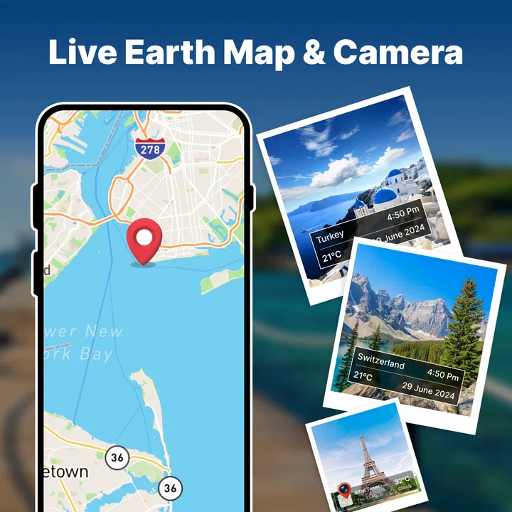
My first few sessions were driven by discovery. The 3D Earth presentation gives ordinary map browsing a more spacious feeling than a flat street map. Instead of seeing only roads and labels, I can think in terms of a whole planet, then move toward a region, a city, or a recognizable landmark. That change in perspective is especially appealing when I am planning a trip, revisiting a place I have seen before, or simply trying to understand where a location sits in relation to the rest of the world.
The landmark views add another reason to browse. They are more engaging than scanning a conventional map when I want visual context rather than the fastest route. I found this useful before looking up a destination for a trip: I could get a broad sense of the place first, then decide whether I needed more detailed navigation. It is also a pleasant way to share a location with someone who is not interested in coordinates or road names.
The live camera element gives the app a different mood from a standard map. A camera view can make a distant location feel current and immediate, even when I am only checking it out casually. I would not use that feature as a substitute for reliable local information, but it makes EarthVista more interesting during short, unplanned sessions. It turns the app from a tool I open only when lost into something I might open because I want to see what is happening somewhere else.
The GPS map is the practical anchor. It keeps the app from being only a digital globe or a collection of scenic views. When I am moving around, seeing my position on a map is more useful than browsing a landmark in isolation. The speedometer also fits naturally into this part of the experience. It can be handy when I want a quick indication of movement without opening a separate utility, though I would still treat it as a convenience rather than equipment for precise driving decisions.
A realistic everyday use is a weekend outing. Before leaving home, I can inspect the destination through the 3D view and landmark presentation, use the map while traveling, and glance at the speedometer when I want a simple movement check. Once I arrive, the same app can return to exploration mode. That continuity is one of its better qualities: the features do not feel completely unrelated when used in the right order.
There is also a useful learning angle. A child or student can use the globe view to connect a landmark with its wider geographic setting. Because the content rating is Everyone, the app is easier to consider for shared family browsing. I would still guide younger users through the interface rather than handing over a phone and assuming every visual element will explain itself, but the broad subject matter is approachable.
Where the early excitement is genuine
The strongest first-week advantage is variety. Many navigation apps are built around one question: how do I get from here to there? EarthVista invites several questions at once. Where is this landmark? What does that area look like? What is my position? How fast am I moving? Can I compare a familiar place with somewhere I have never visited?
That variety makes short sessions easy. I do not need a full journey planned to find a reason to open it. A few minutes of exploring can be satisfying, particularly on a larger display where the 3D presentation has room to breathe. On a smaller phone, the same views can feel more cramped, and the visual appeal depends more heavily on how smoothly the device handles the map.
One non-obvious strength is the ability to change mental modes without changing apps. I can begin with a visual question, move into geographic orientation, and finish with a practical location check. This is more useful than it sounds because it reduces the friction of switching between a globe app, a landmark browser, and a basic speed display. The trade-off is that an all-in-one design may not go as deep as a specialist app in any single area.
Another useful habit is to use the 3D view before the GPS map, not after. Starting with the broader geography helps me understand the destination, while starting directly with a route can make the place feel like a line between two points. For unfamiliar areas, that extra context can make the map easier to remember later.
Whether it earns a place after the novelty fades
The real test is not whether EarthVista is enjoyable during the first week. It is whether I still have a reason to open it during an ordinary month when I am not planning a trip or hunting for a famous view. Here, the answer depends on what I expect from a navigation app.
If I want a dependable daily route planner with deep traffic handling, transit detail, business information, or a highly established local search system, a dedicated mapping service is likely the better choice. EarthVista’s appeal is broader and more visual. It works best as a companion for orientation and exploration, with navigation functions that make it more useful than a purely scenic globe.
For occasional travel planning, its recurring value is easier to see. I can use the 3D Earth view to understand a region, inspect landmark views for inspiration, and then rely on the GPS map during the outing. This workflow gives the app a role before, during, and after a trip. It will not create a reason to travel every month, but it can become a familiar preparation tool whenever a destination appears on my calendar.
The speedometer creates a second type of recurring value. People who like having a quick movement display available may appreciate not needing another app for that small task. I would not call it a decisive reason to install EarthVista by itself, but it helps the app remain useful when the exploration features are not holding my attention.
There is a practical trade-off between convenience and specialization. Having maps, cameras, landmark views, a globe, and a speedometer together is convenient, but I should not assume that convenience means every feature matches the depth of the best standalone alternative. EarthVista earns its space through combination. If I only need one narrow function, another app may be faster and more focused.
How I would build a repeatable routine
To keep the app from becoming a one-session curiosity, I would give each feature a clear job. I would use the 3D view for broad orientation, landmark views for visual planning, live cameras for a quick sense of place, GPS maps for movement, and the speedometer for an immediate travel check. That division prevents me from opening the app without knowing what I want from it.
A useful monthly routine could be as simple as checking an upcoming destination, exploring one unfamiliar region, and using the map during a real outing. The point is not to force daily use. This is not the kind of app that needs to be opened constantly to justify itself. Its value is more episodic, and accepting that makes the experience feel less disappointing.
I also recommend judging the app on a phone rather than assuming the store summary tells the whole story. A 3D map and landmark imagery ask more from the display than a plain list or text utility. If the interface feels crowded or movement is not smooth on a particular device, that is not a minor detail; it changes whether exploration feels relaxing or tiring.
For families, a good recurring use is shared exploration rather than unsupervised browsing. Pick a landmark, find it on the globe, then discuss its location and surrounding geography. This turns the app into a conversation starter instead of another passive scrolling experience. For solo users, the same approach works as a short travel-planning ritual.
The maintenance burden and the small frictions
EarthVista is free, which lowers the commitment required to try it. The current version is 1.2, so I would approach it as an app that may still be developing rather than as a finished replacement for every established navigation tool. That does not make it a poor choice, but it does affect how much responsibility I place on it during important travel.
The main maintenance burden is mental rather than financial: I need to remember which feature is appropriate for which task. A person looking only for directions may find the extra visual layers distracting. Someone interested only in live cameras may feel that the GPS and speedometer functions are unnecessary. The app asks me to accept a little more variety in exchange for a wider range of uses.
There is also a likely attention cost in visual exploration. A 3D globe encourages browsing, and browsing can become aimless. I have to set a purpose if I want to finish a session with something useful, such as understanding a destination’s position or choosing landmarks to investigate. Without that purpose, the app can feel entertaining without becoming part of a stable habit.
When I am driving, I would keep safety ahead of convenience. A speedometer or map display should not encourage me to stare at the screen while moving. The sensible workflow is to prepare before departure, mount the phone appropriately if I am using it for navigation, and interact only when stopped or when a passenger can help. The app’s convenience does not change the basic limits of using a phone on the road.
Another friction is expectation management around the word “live.” A live camera view can be interesting, but it should not automatically be treated as a complete picture of local conditions. Cameras can show one angle at one moment. For weather, road closures, safety decisions, or time-sensitive planning, I would still consult a more specialized local source when the situation matters.
The same caution applies to the speedometer. It is useful as a quick reference, but I would not use a phone-based display to settle a dispute about exact speed or to replace the vehicle’s own instruments. Its value is convenience and awareness, not professional measurement.
Who should use it, and who should skip it
I think EarthVista is a good fit for curious travelers, casual geography enthusiasts, families exploring landmarks together, and drivers who want navigation-related utilities in one place. It is also appealing to anyone who enjoys understanding a destination visually before dealing with the practical details of getting there.
I would recommend it to a friend who says, “I want to see where a place is and get a feel for it, but I also want a map when I go.” That sentence describes the app’s strongest audience. The free price makes experimentation easy, and the Everyone rating keeps the subject matter broadly accessible.
I would suggest skipping it if the only requirement is the fastest, most detailed route planning available. In that case, a specialist navigation service will probably feel clearer. I would also skip it if I dislike visual browsing, because the globe and landmark elements are central to the personality of the app rather than decorative extras.
It may not be the best choice for someone who needs a professional driving instrument, highly precise travel data, or a single-purpose interface with no distractions. EarthVista is more flexible than focused. That is its appeal for some people and its weakness for others.
My long-term verdict
EarthVista: Live Satellite Map earns a place on my phone when I treat it as a hybrid exploration and navigation companion. The 3D Earth view gives it character, the landmark and camera features make browsing more engaging, and the GPS map and speedometer provide enough practical value to support real outings. It is more memorable than a plain map, but it is not automatically a full substitute for one of the major dedicated navigation tools.
Its long-term success depends on recurring situations rather than constant use. I can see myself returning before trips, during weekend exploration, when showing a landmark to someone else, or when I want geographic context that a route line does not provide. I do not see a strong reason to open it every day unless those visual and travel habits are already part of my routine.
The most important trade-off is simple: EarthVista gives me breadth instead of maximum depth. I get several connected ways to look at the world, but I should keep my expectations realistic about specialist-level navigation, camera interpretation, and speed measurement. Used with that understanding, the app feels purposeful rather than gimmicky.
My recommendation is to try it if you want maps to feel more exploratory and you appreciate having travel tools gathered together. Give it a real test on a planned outing, not only a quick spin of the globe. If the combination of visual discovery and practical checking fits the way you travel, it can remain useful well beyond the first-week novelty. If all you need is an exact route from one address to another, a more focused alternative will likely serve you better.
FAQs for EarthVista: Live Satellite Map
01What is EarthVista: Live Satellite Map and what can I use it for?
EarthVista: Live Satellite Map is designed for exploring satellite imagery, maps, and geographic locations from a mobile device. You can use it to view different areas of the world, inspect landscapes, search for places, and learn more about terrain and urban development. It is best treated as an interactive mapping and visualization tool rather than a guaranteed real-time surveillance service.
02Does EarthVista: Live Satellite Map show live or real-time satellite images?
Despite the word “Live” in its name, satellite imagery in mapping applications is usually not updated continuously. Images may come from different providers and can be days, months, or even years old depending on the location. EarthVista may offer live-style map navigation or frequently refreshed data, but users should not assume that they are seeing current events, moving vehicles, or minute-by-minute changes.
03Does the app require an internet connection to work properly?
An internet connection is generally necessary to load satellite imagery, map tiles, place searches, and other online content. Performance may vary with mobile data coverage and connection speed, especially when zooming into detailed areas. Before traveling, check whether the app supports offline maps or cached content, because previously viewed imagery may not remain available without an active connection.
04Is EarthVista: Live Satellite Map free to download and use?
The application may be available to download at no initial cost, but some features can depend on advertising, subscriptions, or in-app purchases. Premium access might remove ads, unlock additional map layers, provide enhanced imagery, or enable extra tools. Always review the current store listing, pricing details, trial conditions, and renewal terms before confirming a purchase.
05Does EarthVista: Live Satellite Map collect location or personal information?
The app may request location access to center the map around your current position or improve location-based features, although browsing other places may not require this permission. Before installation, review the privacy information shown on the Google Play Store or Apple App Store. Consider disabling unnecessary permissions and checking how location, device, usage, and diagnostic data may be collected or shared.
Pros
- Clear satellite imagery makes it easy to explore cities
- landscapes
- and remote areas.
- Live location support helps users compare their position with surrounding terrain.
- Smooth map navigation with familiar zoom
- pan
- and search controls.
- Useful for trip planning
- geography learning
- and virtual exploration.
- Available on mobile devices for convenient viewing away from a desktop.
Cons
- Satellite imagery may not be truly live and can vary in age by location.
- Image quality and detail differ significantly between regions.
- Some features may require an internet connection and consume mobile data.
- Map loading can feel slower on older phones or weaker networks.
- Privacy-conscious users may dislike location access requirements.

EarthVista: Live Satellite Map
Gallery